 |
|
Obscure locations in the area of the |
Rural Municipality Chesterfield No. 261 |
, Saskatchewan |

While researching the people buried in the two cemeteries, I learned about some named locations in the area that you could call "obscure". There may be nothing at the locations anymore, but the names were important in the past, and were mentioned in official records and/or newspapers.
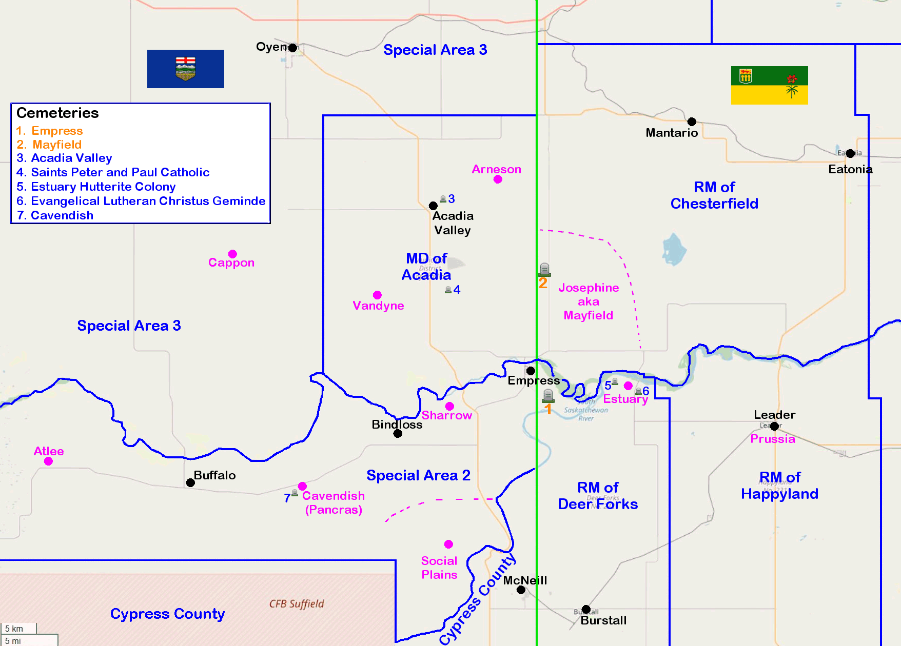
| CGNDB = Canadian Geographical Names Database Map = Alberta Homestead Maps - circa 1918 (Courtesy of the University of Lethbridge) | ||||
| Arneson, AB | 51.1866667, -110.075 | CGNDB | Map 64A (page 7) | |
| Atlee, AB | 50.8416667, -110.9502778 | CGNDB | Wikipedia | |
| Cappon, AB | 51.1008333, -110.6030556 | CGNDB | Wikipedia | |
| Cavendish, AB (aka Pancras) | 50.8155556, -110.4552778 | CGNDB | Wikipedia | Map #54A (page 7) |
| Estuary, SK | 50.93539, -109.8183 | CGNDB | Wikipedia | |
| Josephine aka Mayfield, SK | An unofficial area not associated with the RM of Mayfield, which is far to the northeast. | |||
| Prussia, SK (now Leader, SK) | 50.8889827, -109.5419457 | CGNDB | Wikipedia | |
| Ruddington, AB | 50.806717, -110.261692 | Map #53A (page 5) | ||
| Sharrow, AB | 50.9122222, -110.1766667 | CGNDB | Map #53A (page 5) | |
| Social Plains, AB | 50.733333, -110.18333 | CGNDB | Map #53 (page 4) | |
| Vandyne, AB | 51.05, -110.31667 | CGNDB | Map #64 (page 6) | |
|
Social Plains & Ruddington, Alberta Generally, an area of farms:
Ruddington was never official, though it was given on one death record I found (1920). The Social Plains school still exists and has been turned into the Social Plains Community Hall. |
Bruce A. Johnson - Volunteer caretaker & record keeper for the Empress Cemetery.
Empress, Alberta, Canada
Empress, Alberta, Canada