 |

|
|
|


|
|||
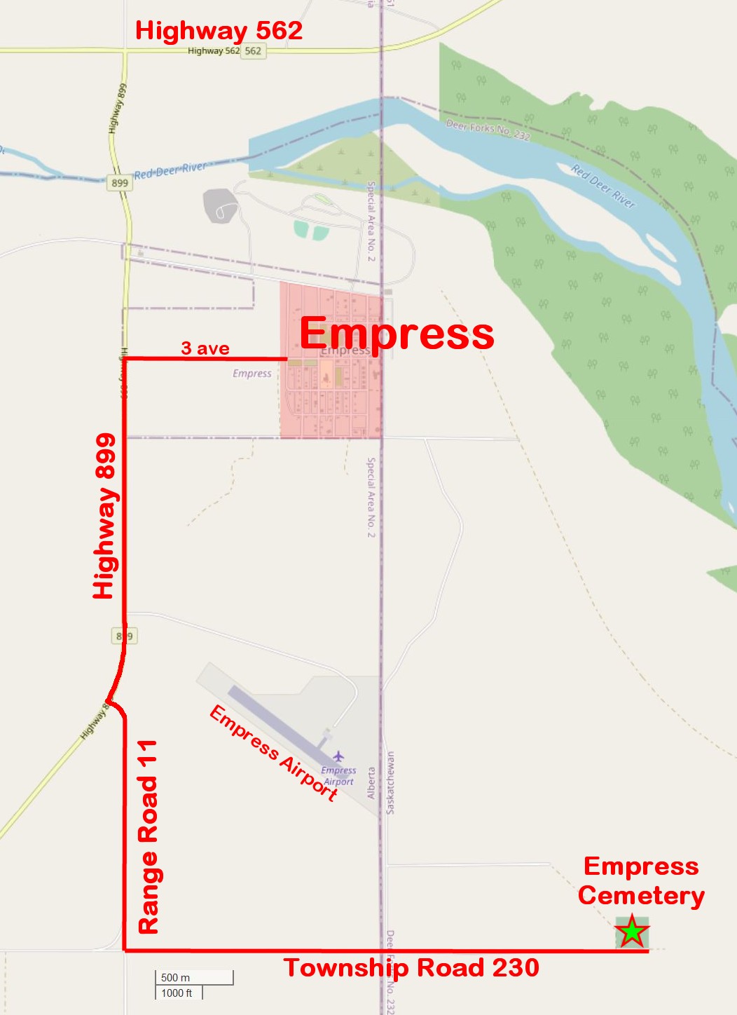
The Village of Empress, Alberta is right on the border with Saskatchewan,
and the Empress Cemetery is 4.2 km southeast in Saskatchewan,
in the Rural Municipality of Deer Forks.
The Empress Cemetery is owned and operated by The Village of Empress, Alberta.
They have limited funds for maintenance, and their policy is that maintenance of graves is the responsibility of the families of the deceased.
You can see the Empress Cemetery Bylaw (2018-08), here, or on the Village website.
This website (EmpressCemetery.ca), is not associated with The Village of Empress
 Empress Cemetery Report 2025-Nov-27
| GPS Coordinates: 50.922367, -109.981017 | |
|---|---|
| SE¼ of 01-04-23-29-W3 R.M. of Deer Forks No. 232 |
|
| Google Maps Android Phone |
Apple Maps iPhone link |
| what3words (///escaped.amid.custody) |
OpenStreetMap |
| Directions below | |
Find a Grave®: Empress Cemetery
Maps & Directories
| These are PDF files with clickable links. | |||
| Item | Release Date | Pages | Page Size |
|---|---|---|---|
| Detail Map | 2026-Jun-02 | 1 | 146 x 247 cm |
| Full Directory | 2026-May-29 | 25 | 90.42 x 27.94 cm |
| Overview Map | 2025-May-12 | 1 | Letter (21.59 x 27.94 cm) |
| Basic Directory | 2026-May-29 | 15 | Letter (21.59 x 27.94 cm) |
| Graves Without Headstones | 2025-Oct-04 | 3 | Letter (21.59 x 27.94 cm) |
| Graves Without Headstones, but with problems | 2025-Aug-11 | 1 | Letter (21.59 x 27.94 cm) |
| The Full Directory and the Big Map contain links that lead to individual Bio pages for each person when I have done some research on them and their family. I will add more as my research continues. | |||
360° pan view from the centre of the cemetery
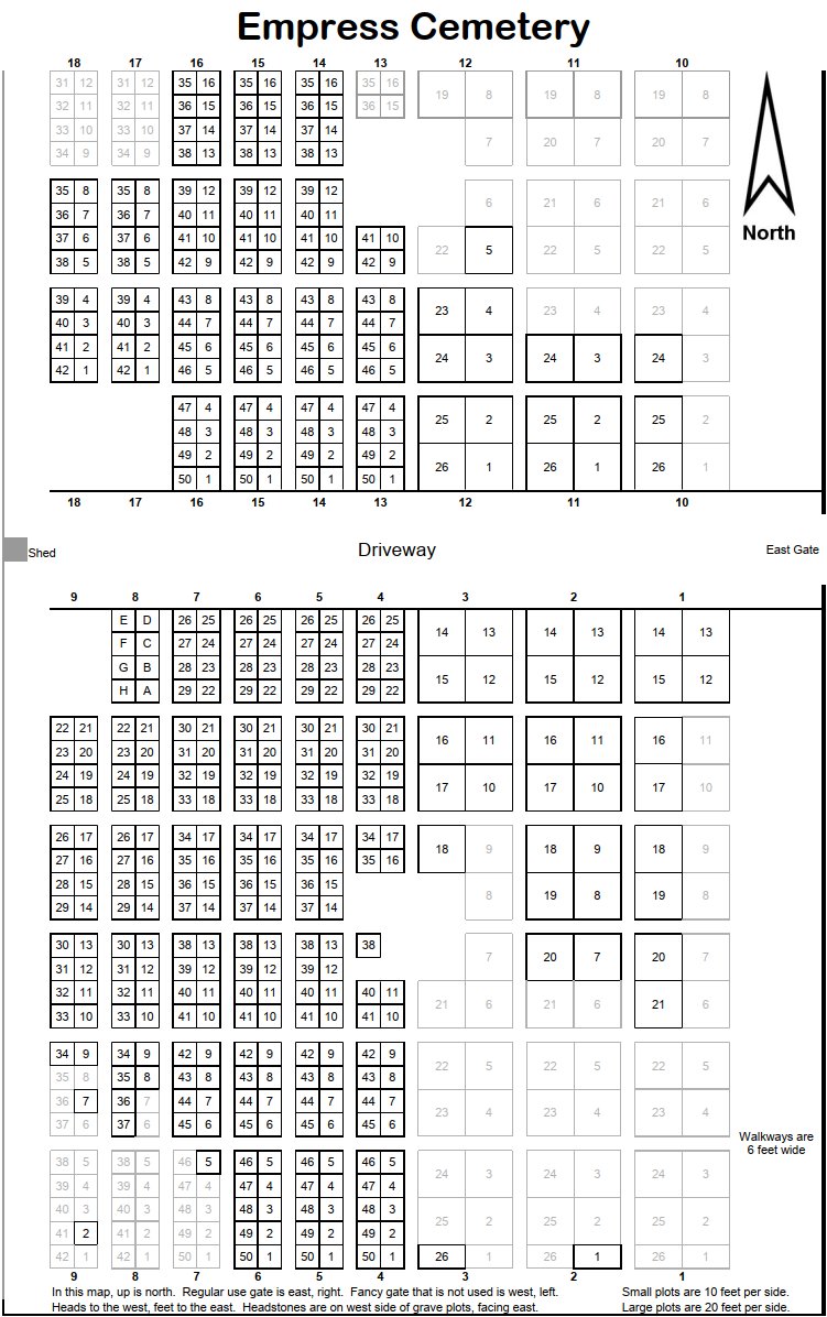
Columns, Plots and Sub-plots
| Columns run north-south. Each individual square is a Plot and inside it are Sub-plots (or graves). The Plot numbers start in the south on the east side of the column, counting up going north. When reaching the farthest north in the column, turns around and continues counting up going south on the west side of the column. So the south end of the columns have both the first Plot number (1), and the highest Plot number just to the west of Plot 1. | |||||||||
Each grave is 10 feet long (east-west), and 5 feet wide (north-south). Walkways are 6 feet wide. These are all "ideal" measurements. The real measurements, and even the exact placement of a grave, can be a little "off" from the plan. |
|||||||||
| |||||||||
| Sub-plot/Grave "M" means middle, when a grave can only be described as being in-between other graves. Sub-plot/Grave "W" means walkway, when a grave was placed in a walkway. | |||||||||
| Sub-plot labeling | |
|---|---|
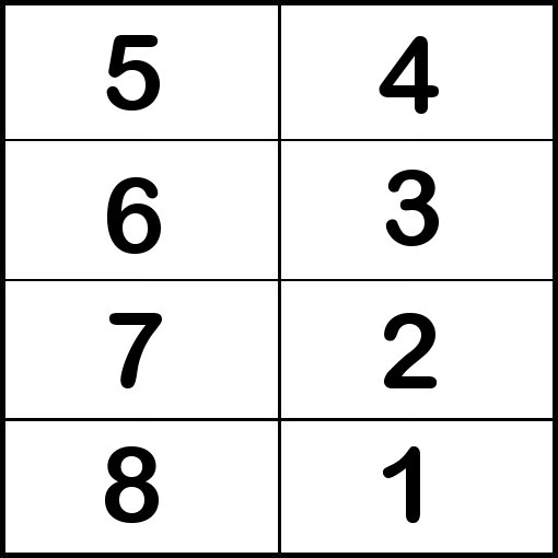 |
Large Plots are 20 feet to a side and contain 8 graves. All have the same Sub-plot/Grave labeling scheme. |
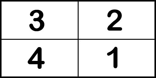 |
Middle-sized Plots are 20 feet east-west and 10 feet north-south, containing 4 graves. All have the same Sub-plot/Grave labeling scheme. They are only at the south ends of columns 1, 2, 3. |
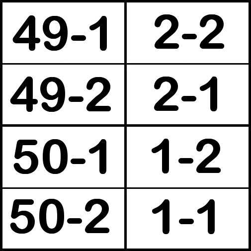 |
Small Plots are 10 feet to a side and contain 2 graves. They have a different Sub-plot/Grave labeling scheme, depending on whether the Plot is on the east side of the Column, or the west side of the Column. Here is an example of the south end of a Column, where the Plot numbers are 1, 2, 49, 50. |
Other Links
Directions
| Directions map I made a few years ago for another website: |
 |
Sped-up dashcam video I made of the Drive from Empress to the Empress Cemetery: |
|
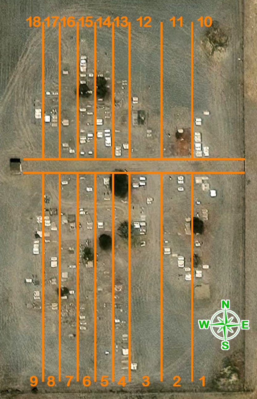
| Annotated satellite map of the cemetery: | 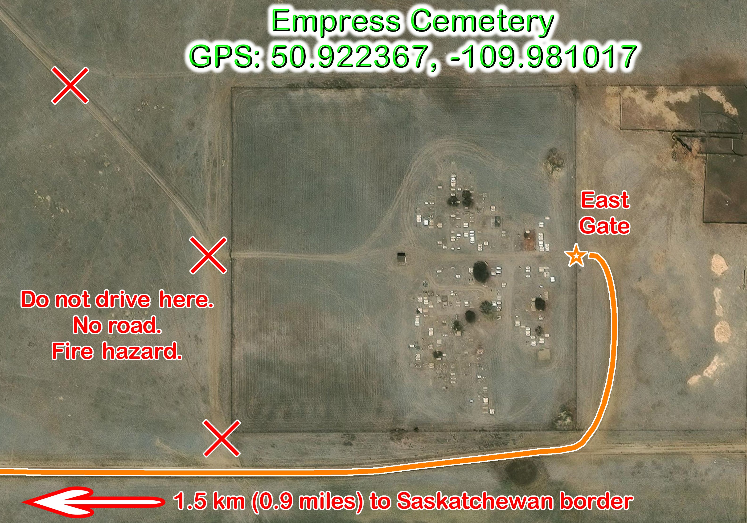 | ||
| GPS Coordinates: 50.922367, -109.981017 | |
|---|---|
| SE¼ of 01-04-23-29-W3, R.M. of Deer Forks #232 | |
| Google Maps Android Phone |
Apple Maps iPhone link |
| what3words (///escaped.amid.custody) |
OpenStreetMap |
| The Bruce's Graveyards group of websites are not monatized, meaning I do not make any money from these websites. There are no advertisements. Bruce A. Johnson - Empress, Alberta, Canada |
Do you have any corrections, concerns, questions, or comments? I'd happy to discuss them. |